
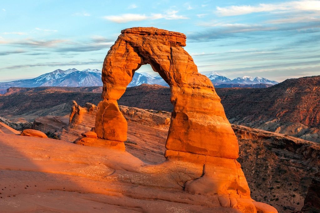
Arches and Canyonlands sit a few miles apart on the Colorado Plateau outside a small town in southeast Utah, and they share the same red Entrada and Cedar Mesa sandstone, the same dry air and the same ferocious summer sun. Yet they feel like different planets. Arches is compact, road-served and busy, a place of single famous landmarks. Canyonlands is enormous, split into districts by rivers with no bridges, and its Needles district in particular is a hiker’s park where the day starts to feel wild about ten minutes from the trailhead. We think the ideal weekend pairs the two: Delicate Arch in the evening light on the first day, and a long loop through the Needles on the second.
Getting into Arches
Arches has become so popular that in recent years the park has required a timed-entry reservation for daytime arrivals during the busy season, roughly spring through fall, on top of the regular entrance fee. Reservations are released months ahead with a small number held back for the day before. Arrivals before early morning or after late afternoon have not needed one, which suits a sunset hike perfectly. Rules change from year to year, so check the current system before you drive out. Once inside, the single paved road climbs the cliff behind the visitor center and runs 18 miles (29 km) to the Devils Garden at the far end, with the Delicate Arch trailhead about 13 miles (21 km) in.
Delicate Arch: the hike
The trail to the most famous arch in the world is 3 miles (4.8 km) round trip with 480 feet (146 m) of gain, and it should take about two to three hours with a long stay at the top. It starts at a historic ranch cabin by a creek, crosses a footbridge and passes a short spur to a panel of petroglyphs pecked into the rock a few centuries ago. Then the trail becomes a broad slope of bare slickrock, marked by cairns, that climbs steadily for half a mile with no shade at all. The final stretch is a ledge cut into a cliff, about 200 yards (180 m) long and wide enough to feel safe, and then the arch appears all at once on the rim of a natural sandstone bowl. It stands 52 feet (16 m) tall on the edge of a drop, with the snow-capped peaks of the La Sal Mountains framed in the opening.
Why sunset, and how to do it well
The arch faces west, so in the last hour before sunset the sandstone turns from orange to a deep glowing red while the mountains behind it go blue. It is also the busiest hour of the day at the arch. There will be a line of people waiting to walk into the opening for a photograph, and the polite convention is to take your turn, step out, and let the next person in. Arrive at least an hour before sunset to claim a seat on the rim of the bowl, bring a headlamp for the walk back across the slickrock in the dark, and carry more water than you think a short hike deserves; the slope is hot even at 6 p.m. in summer. If the crowd is not for you, the lower and upper viewpoints on the other side of the wash, reached by short trails from a separate parking lot, give a distant view of the arch on its ridge, and the upper one is worth the half-mile climb.
The Needles: a different scale
The Needles district of Canyonlands lies about 75 miles (120 km) by road south of Arches, down a long side road that passes a famous petroglyph panel on a state historic site before entering the park. The name comes from the banded pinnacles of Cedar Mesa sandstone, striped red and white, that rise in ranks across a grassland of tall grass and cryptobiotic soil. There is one campground inside the park, a visitor center, a short paved road, and then dirt, slickrock and silence. Short walks from the road include Cave Spring, 0.6 miles (1 km) through a historic cowboy camp and up two ladders, Pothole Point, also 0.6 miles, and the Slickrock Foot Trail, 2.4 miles (3.9 km) of cairned rock with four viewpoints over the canyons.
Chesler Park and the Joint Trail
The great day hike of the Needles is the Chesler Park Loop, about 11 miles (17.7 km) from the Elephant Hill trailhead. The route climbs over slickrock passes, drops into a meadow completely surrounded by spires, then works through the Joint Trail, a fracture in the rock so narrow that you walk in single file under a ceiling of stone for several hundred yards. The return crosses more open rock and a section of four-wheel-drive road. Count on six to eight hours with a total gain and loss around 1,500 feet (460 m). If that is too long, the out-and-back to the Chesler Park viewpoint is 6 miles (9.7 km) and gives you the meadow without the joint. Druid Arch, at the head of Elephant Canyon, is the other great objective at 10.8 miles (17.4 km) round trip, finishing with a scramble up a ladder and a steep slab to a massive stone arch that looks like a standing stone circle. Overnight trips into Chesler Park and beyond require a backcountry permit reserved well ahead, and the campsites are among the finest in the desert Southwest.
Practical points for both parks
- Water: there is none on any trail in either park. Carry a gallon (4 liters) per person for a full Needles day and at least a liter for Delicate Arch.
- Season: March to May and mid-September to early November are ideal. Summer highs exceed 100 F (38 C) on the slickrock, and July and August bring flash-flood storms.
- Navigation: both loops in the Needles are cairned but not signed at every junction; carry a map and know how to read it.
- Soil: the black crust on the sand is alive and takes decades to regrow. Walk on rock, in washes or on trail, never across it.
- Sunset timing: after the arch, the drive back to the park entrance takes 30 minutes in the dark; deer are on the road.
Do the arch first because it is the postcard everyone came for, and then go to the Needles because it is where the postcards stop and the desert begins.